
Cyclone Gabrielle continues to move southeast down the upper North Island, bringing severe weather with it.
Tens of thousands of homes are without power across Northland, Auckland and Coromandel as severe wind gusts and rain lash the upper northern region.
The weather system poses a “very high risk of extreme, impacted and unprecedented weather” over many regions of the North Island through to Tuesday.
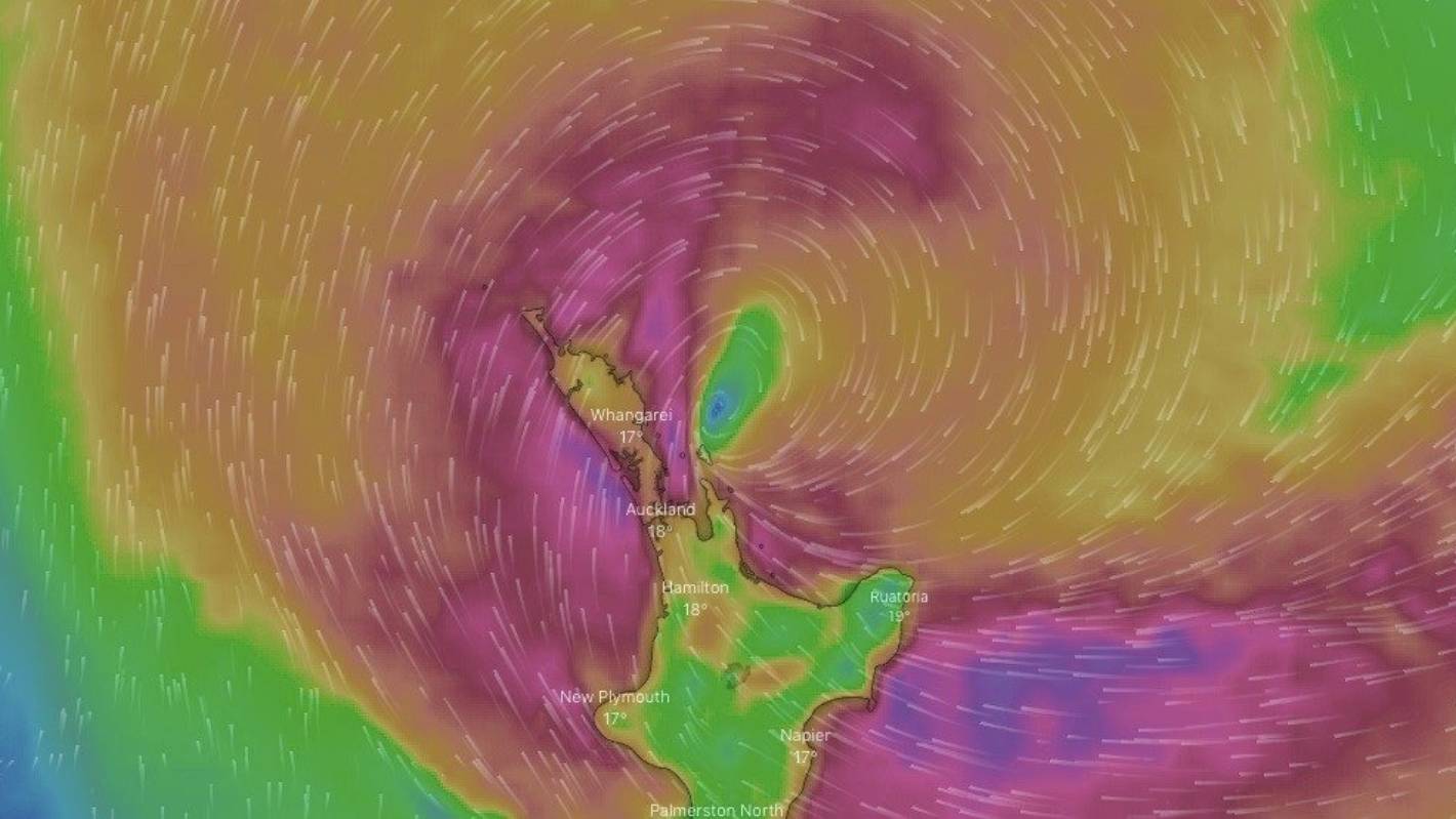
As of 1pm, Cyclone Gabrielle was sitting about 250km to the north, northeast of Great Barrier Island, MetService meteorologist Peter Little said.
READ MORE:
* Live: Wild winds, severe rain, power outages as Cyclone Gabrielle lashes the north
* Cyclone Gabrielle: Some Northlanders could be without power for a week
* All eyes in Tairāwhiti looking west as heavy rain expected to push slash down hills
* Tail end of Cyclone Gabrielle to bring wind and rain to South Island
The system was moving southward, generally southeasterly. From 9am, when it was roughly 250km north of Cape Reinga, it was now sitting about 310km to the east of the cape, Little said.
earth.nullschool.net
The projected path of Cyclone Gabrielle shows the storm hitting Great Barrier in the early hours of Tuesday and bouncing away to the east.
Cyclone Gabrielle is forecast to continue to take a more southerly course, bringing it down to Great Barrier (just shy of 100km from Auckland), and Coromandel Peninsula on Monday night.
It is then set to “wiggle” a bit – tracking southeast away from the mainland, toward the north of East Cape on Tuesday evening, Little said.
As it moves southeast over 36 hours, the angle of winds across the upper North Island will change as they wrap around the moving centre, but the wind speed is set to stay “very high”, MetService says.
Breakfast
Meteorologist Chris Brandolino explained what the North Island can expect from Cyclone Gabrielle.
On Monday afternoon, MetService meteorologist Georgina Griffiths said, there was a bit of a “pause” as the wind is turning in Tāmaki Makaurau, as of 2pm, but that they are monitoring a line of heavier rainfall – “downpour-type rain rates” – sitting off the west coast of Auckland.
“We expect some of those heavier falls start to roll back in to Auckland later this afternoon, this evening and tonight. That is why we still have a red heavy rain warning in force.”
Because Auckland is already so saturated, they expected to see some localised impacts, including flooding and slips.
However, MetService did not expect all of Auckland will see these “high intensity” rainfalls, it would be pockets of the region.
“Unfortunately it’s a little bit like confetti” where the pockets of heaviest rain will fall across the region, she said: “it’s really difficult to determine – even looking at the radar, it’s pretty spotty”.
Griffiths noted that Great Barrier Island “might not see any pause” as Cyclone Gabrielle is tracking “very close” to the east of the island on Monday night.
“The Barrier is in for a hard night.”
For all of Auckland, though, MetService expects the wind to come back on Tuesday from another direction.
Parts of Auckland which have not yet seen “damaging or challenging wind conditions are likely to see a period of severe southwest gales tomorrow”, she said.
As of 5pm on Monday, red heavy rain warnings remain for Northland, Auckland, Coromandel Peninsula, Gisborne (north of Tolaga Bay) and Tolaga Bay southwards, and Hawke’s Bay.
Red strong wind warnings are in force for Northland, Auckland, Coromandel Peninsula and Taranaki.
SUPPLIED
Cyclone Gabrielle will affect eastern parts of the North Island on Wednesday, according to MetService’s tracking map issued at 1pm on Monday.
Orange wind warnings blanket all remaining North Island locations, as well as the top half of the South Island, meaning wind damage is possible almost anywhere.
Niwa forecaster Chris Brandolino said the system would likely reach its point closest to Auckland some time late on Monday.
Those in the region should prepare for it to rain “very hard” on Monday night.
Given the path of the storm, Brandolino said the worst weather for Auckland and Coromandel could happen from roughly 6pm on Monday to 6pm on Tuesday. It could include strong winds, heavy rain or both.
What next?
Cyclone Gabrielle is expected move away to the southeast of the North Island during Wednesday morning, and pass to the north of the Chatham Island during Wednesday evening, MetService says.
Associated heavy rain, potentially damaging winds and large waves affecting much of the North Island, the upper South Island and the Chatham Island are expected to ease on Wednesday.
Brandolino said the amount of rain forecast to fall in Auckland over 24 hours could be double or even triple what was seen in a typical February – potentially causing flooding issues and slips.
As the cyclone tracked further down the island in a southeasterly direction, rain may be “not as persistent” or as heavy mid-morning on Tuesday, but the winds would remain a “big factor” across the Auckland region, Brandolino said.
Brandolino said you could think about the weather system like a top spinning. As the top went towards the south and the east, heavy winds would flick around it and back up.
It was a “sliding scale”, he said: the first parts of the country to be hit would be the first to improve, but in eastern parts of the North Island – Gisborne, Hawke’s Bay, and down to Wellington and the Tararuas – heavy rain was set to persist into Wednesday, when Marlborough and North Canterbury could also expect to be hit.


