Aerial views of flooding in Hawke’s Bay as Cyclone Gabrielle hit the region. Photo / Supplied via Corena
Red stickers have been placed on 750 buildings across the upper and eastern North Island after the Auckland floods and Cyclone Gabrielle, and more placards are likely to come as assessments of the damage continue.
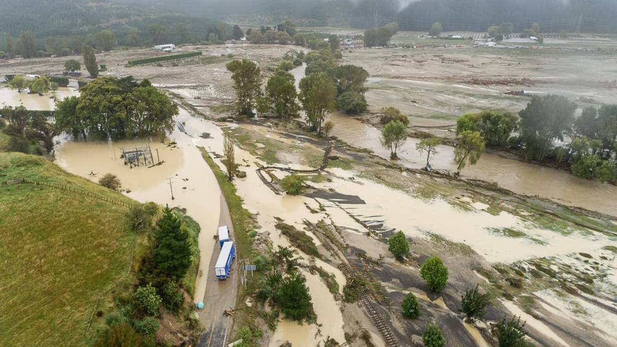
The almost back-to-back weather events caused destruction and devastation for North Island communities.
Torrential rain caused slips to come down through people’s homes, destroying livelihoods and in some cases, claiming lives.
The official death toll from Cyclone Gabrielle is 11; the majority of the deaths were in Hawke’s Bay.
Advertisement
Since the Auckland floods in late January to March 2, 750 buildings have been red-stickered, meaning they cannot be entered because of damage.
There are now 3588 yellow-stickered buildings, where access is restricted, and 4673 buildings with white stickers, meaning they can be used but may not be safe because of unseen damage.
Most of the red-stickered buildings are in Auckland (584). Of these, 357 were due to the late January floods and 227 due to Cyclone Gabrielle.
In Hawke’s Bay, one of the regions hit hardest by Cyclone Gabrielle, thousands of people were still without electricity as of yesterday morning, mostly in outlying rural areas, and lengthy parts of key roads connecting Napier to the rest of the country were still closed.
Advertisement
Areas such as Esk Valley, Puketapu, Dartmoor and Pakowhai in Hawke’s Bay were devastated by the raging flood waters, silt and mud when the cyclone struck.
Seventy-nine buildings have been red-stickered in Hastings, four in Napier, three in Wairoa and one in central Hawke’s Bay.
In Northland, more than 100 local roads are still closed after the cyclone barrelled through the region, displacing residents and isolating communities, including a community on Takitu Rd, around 42km north of Dargaville, that was trapped without power after enormous slips blocked rivers and roads and cut them off from society.
/cloudfront-ap-southeast-2.images.arcpublishing.com/nzme/SGSBPJ5A5RGAXC32HPDO53XQTE.JPG)
Twenty-eight buildings in the Far North have been red-stickered.
In Thames, 13 have been condemned, and in Tairāwhiti, there are 11 red-stickered properties.
State of emergency status has been lifted in the Auckland, Waikato and Tararua districts almost three weeks after the arrival of Cyclone Gabrielle.
But they still remain in place for Hawke’s Bay and in Tairāwhiti where people living in small settlements along the East Coast went without a stable form of connection for weeks.
For red or yellow-stickered properties, the amount of damage the building has suffered means access is restricted or prohibited.
Yellow-stickered properties have sustained moderate damage. Access may be restricted to some of the building only or could be limited to short-term entry only.
Properties with red-stickers, the highest of the three placards issued by inspectors, have sustained moderate or heavy damage and cannot be entered as they pose a significant risk to health or life.
Advertisement