
Windy/Supplied
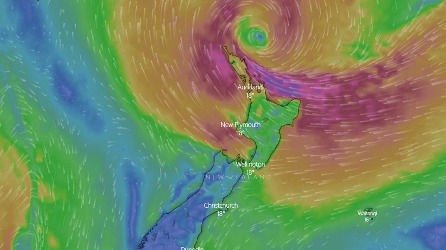
Cyclone Gabrielle was sitting 250km north of Cape Reinga on Monday morning.
Cyclone Gabrielle’s impacts are already being felt across much of the upper North Island, even as it sits roughly 250km north of Cape Reinga.
Tens of thousands of homes are without power across Northland and Auckland as severe wind gusts and rain lash the upper northern region.
The weather system poses a “very high risk of extreme, impacted and unprecedented weather” over many regions of the North Island through to Tuesday.
MetService meteorologist Alwyn Bakker said the former tropical cyclone system was sitting a couple of hundred kilometres almost directly north of Great Barrier Island, as of 9am on Monday.
READ MORE:
* Live: Wild winds, severe rain, power outages as Cyclone Gabrielle lashes the north
* Cyclone Gabrielle: Some Northlanders could be without power for a week
* All eyes in Tairāwhiti looking west as heavy rain expected to push slash down hills
* Tail end of Cyclone Gabrielle to bring wind and rain to South Island
Over the next 24 hours, forecasters are expecting it to come closer to Great Barrier – just shy of 100km from Tāmaki Makaurau (Auckland) – before it would start heading southeast, towards the Coromandel, Bay of Plenty and eventually to Gisborne.
Bakker said there was always “uncertainty” with the position and tracking of a cyclone.
The later in the week forecasters looked, the more that uncertainty broadened.
Breakfast
Meteorologist Chris Brandolino explained what the North Island can expect from Cyclone Gabrielle.
Cyclone Gabrielle continued to track relatively close to what had been forecast, he said.
“We can say with pretty good certainty that [Gabrielle] will come closer to Great Barrier Island today.”
As it tracked closer, the impacts for Auckland greatened, he said.
It was expected these impacts will then spread south across the rest of the North Island – including the eastern Bay of Plenty and Gisborne – through to northern parts of the South Island through Monday and Tuesday.
MetService/Supplied
Cyclone Gabrielle was due to come close to Auckland on Monday evening.
Bakker said regardless of the storm’s path, the impacts would be widespread across the North Island in the coming days.
“Now’s a very good time to be paying attention to [MetService] watches and warnings.”
Niwa forecaster Chris Brandolino said the system would likely reach its point closest to Auckland sometime late on Monday.
Those in the region should prepare for it to rain “very hard” on Monday night.
Given the path of the storm, Brandolino said the worst weather for Auckland and Coromandel could happen from roughly 6pm on Monday to 6pm on Tuesday. It could include strong winds, heavy rain or both.
Supplied
Cyclone Gabrielle will impact eastern parts of the North Island on Wednesday.
Brandolino said the amount of rain forecast to fall in Auckland over 24 hours could be double or even triple what was seen in a typical February – potentially causing flooding issues and slips.
As the cyclone tracked further down the island in a southeasterly direction, rain may be “not as persistent” or as heavy mid-morning on Tuesday, but the winds would remain a “big factor” across the Auckland region.
Brandolino said you could think about the weather system like a top spinning. As the top went towards the south and the east, heavy winds would flick around it and back up.
It was a “sliding scale”, he said: the first parts of the country to be hit would be the first to improve, but in eastern parts of the North Island – Gisborne, Hawke’s Bay, and down to Wellington and the Tararuas – heavy rain was set to persist into Wednesday, when Marlborough and North Canterbury could also expect to be hit.


