- Cyclone Gabrielle is heading towards Aotearoa and the first effects are expected to be felt in Northland on Sunday.
- The states of emergency in Thames-Coromandel and in Auckland have been extended.
- MetService is predicting severe weather for the upper North Island from Monday, but Gabrielle’s path and specific effects are still yet to be confirmed.
- Gabrielle has reached a category 3 severe tropical cyclone status as it moves towards Aotearoa.
- E haramai ana a Huripari Gabrielle ki Aotearoa, ā, e kawatau nei ka pāngia tuatahitia mai hei ā Hanarei i Te Tai Tokerau.
- Kua whakatōroa ake ngā whakataunga ohotata ki Pārāwai, Te Tara o te Ika, me Tāmaki Makaurau.
- Hei tā te matapae a Te Ratonga Tirorangi ka hūkerikeri te huarere ki te Puku me te Hiku o Te Ika hei ā Mane, engari kāore anō kia āmiki whakatauria te huarahi ka takahia e Gabrielle.
- Kua eke a Gabrielle ki te taumata 3, arā te huripari pārūrū kino, i tōna kokenga mai ki Aotearoa.
Cyclone Gabrielle has intensified into a category 3 severe tropical cyclone and is now expected to travel down the east of New Zealand, according to Niwa.
On Friday morning, Gabrielle is off the coast of Queensland in the Coral Sea and is moving southeast towards Aotearoa.
It is expected to make landfall early on Tuesday on the eastern side of Northland – but bad weather will start from Sunday, according to experts.
Niwa/Supplied
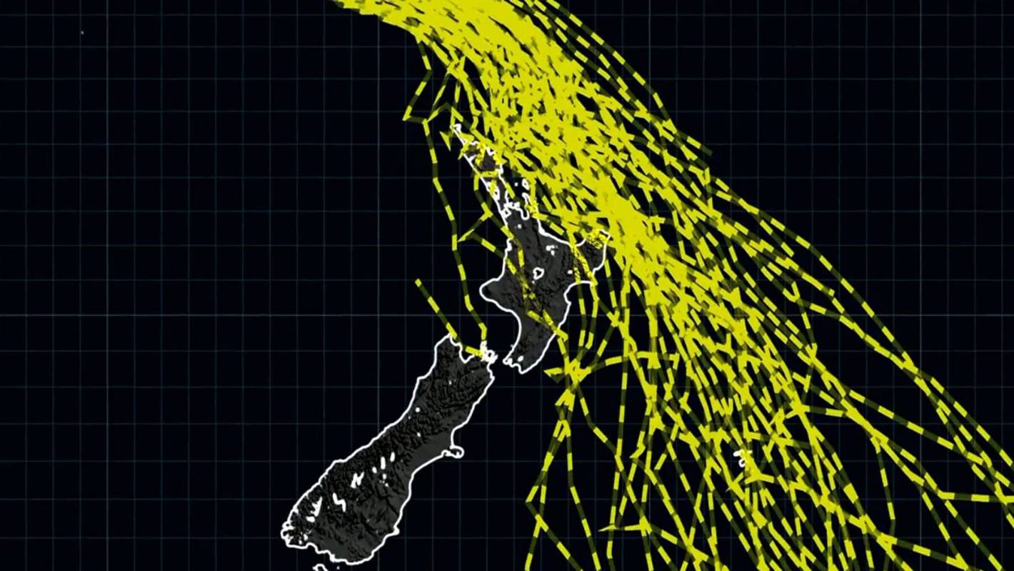
Niwa has updated the forecast routes that Gabrielle could take, they are further east than Thursday’s prediction.
The latest Niwa forecast shows Gabrielle is most likely to track down the eastern side of New Zealand.
READ MORE:
* Cyclone Gabrielle could hammer Coromandel with up to 300mm of rain in 24 hours
* Coromandel extends state of emergency as Cyclone Gabrielle approaches
* Tropical Cyclone Gabrielle set to barrel toward New Zealand
Niwa’s Chris Brandolino said Gabrielle’s tracking was still an uncertain forecast, but the likely eastward tracking meant the worst of the weather is most likely to be felt by Coromandel and the Bay of Plenty.
The meteorologist said residents there should be prepared for slips, widespread flooding, coastal inundation and power outages.
Brandolino said Gabrielle’s likely eastward track down the Hauraki Gulf or over Great Barrier meant Auckland would still receive significant severe weather, but it could “barely escape” being the country’s worst hit area.
Bay of Plenty and Coromandel could be in for 250mm-350mm Brandolino said.
“Odds are that it will track east, the question is: how far east?” he said.
“Auckland’s good news is maybe someone else’s bad news, but that’s not certain yet.”
Supplied
Cyclone Gabrielle as it approaches New Zealand. Image taken at 9.40am NZT, Feb 10, 2023
The Australian Bureau of Meteorology says Gabrielle’s wind speed is currently 120kph with wind gusts to 165kph.
The bureau made the call to upgrade Gabrielle turned into a category 3 storm off data received at 5am Australian eastern time, or 8am NZ time.
A category 3 tropical cyclone, with the upgraded “severe” designation, has an average wind speed of between 119kph and 157kph.
It is moving southeast towards NZ at 36kph.
Gabrielle is not expected to reach category 4 status.
A heavy rain watch is in place for Coromandel, along with Northland and Auckland north of Whangaparāoa, from Sunday morning through to midnight Tuesday.
According to MetService forecaster Aidan Pyselman, while the bad weather would start late on the weekend, the cyclone wouldn’t actually make landfall until early Tuesday.
It would touch down on the eastern part of Northland, before heading down into Auckland, he said.
The cyclone was expected to then roll down the country through Tuesday and into Wednesday, heading east, Pyselman said.
“It’ll then drop down into Hawke’s Bay.”
It was still a few days out and models might change, he said.
According to MetService, between 200-300mm of rain could fall in Coromandel in the 24 hours from Monday morning to Tuesday morning.
Auckland and Northland could see between 150-200mm of rain in the same period.
A strong wind watch is also in force for Northland and Auckland north of Whangaparāoa from 6am Sunday to midnight Tuesday.
Auckland south of Whangaparāoa and Coromandel Peninsula have a strong wind watch from 6am Monday to midnight Tuesday.
MetService/Supplied
Tropical Cyclone Gabrielle is expected to hit the eastern side of Northland on Tuesday.
“If the cyclone continues on its current path towards the north of Aotearoa New Zealand, we can expect this to be an extreme weather event with widespread damage,” MetService’s head of weather communication Lisa Murray said.
“Those areas that are already vulnerable following last week’s weather are expected to see more rain, strong wind, heavy swells and coastal inundation which will exacerbate the situation.”
On Thursday night, Auckland mayor Wayne Brown extended the region’s state of emergency for another week ahead of Gabrielle making land.
The state of emergency has been in place since January 27, when torrential rain caused devastating flooding, killing four people.
Abigail Dougherty/Stuff
Multiple roads in Auckland’s west were blocked by landslides following the January 27 floods.
“My decision reflects the seriousness of the current and potential situation and our response,” Brown said on Thursday afternoon.
“After what Aucklanders have experienced since Friday 27 January, and with our region waterlogged, it will be a very serious situation if the current weather forecasts eventuate.”
People have been urged to get three days of supplies together in case they are stuck at home due to flooding and slips.
Twenty-one evacuation centres will open in Auckland in case of mass displacement.