
Thunderstorms are expected to sweep across the North Island overnight, which could make for wild conditions for morning commuters on Wednesday.
MetService issued a severe thunderstorm watch alert on Tuesday evening that affects most of the North Island, including Northland, Auckland, Great Barrier Island, Coromandel Peninsula, Waikato, Waitomo, Taumarunui, Bay of Plenty, Rotorua, Taupo, Taranaki, Taihape, and Whanganui.
“Active bands of thunderstorms are expected to move eastwards across the North Island Tuesday night and early Wednesday morning,” a statement from MetService said.
“Some of these thunderstorms may be severe, producing damaging wind gusts in excess of 110kph and possibly a small tornado. In addition, for regions south of Northland localised downpours of 25 to 40 mm/hr are possible.”
READ MORE:
* Sand top-up for popular Wellington beaches a shore thing
* Mighty oak crushes classroom and kids’ dreams of a happy end to the school year
* Sound ‘like thunder’ before massive tree toppled onto commuter
MetService/Supplied
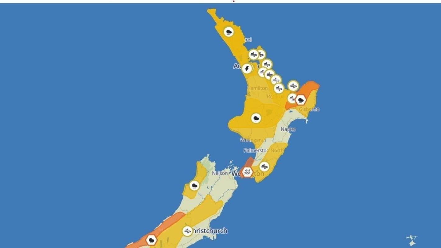
MetService weather watches issued on Tuesday morning cover most of the North Island.
The warnings are in place from 9pm Tuesday to 3am Wednesday. MetService added that squally winds and possible small tornadoes may cause some structural damage, including damage to trees and power lines, which could make driving hazardous.
If any tornadoes occur, they will only affect very localised areas.
Rainfall of this intensity can cause surface and or flash flooding, especially in low-lying areas near streams, rivers or narrow valleys.
Such conditions may also lead to slips.
Earlier on Tuesday, Auckland’s motorists were warned that a high wind alert could force the closure of the Harbour Bridge.
Waka Kotahi New Zealand Transport Agency (NZTA) is warning motorists that a high wind alert has been issued for the Harbour Bridge, and lanes could close between 8pm and midnight.
Motorists are urged to drive to the conditions, look out for electronic message boards which will indicate lane closures and reduced speeds, and stay within their lane while travelling across the bridge.
Drivers of high-sided vehicles and motorcyclists are advised to avoid the Auckland Harbour Bridge and use the western ring route on State Highways 16 and 18.
The windy conditions could also cause delays or cancellations to public transport.
As a result of the high wind alert, there will be no barrier shift today and the lane configuration will remain four in each direction.
Supplied
A high wind alert could force the closure of the Auckland Harbour Bridge.
Waka Kotahi said they are working closely with MetService to monitor wind speeds with maintenance crews out on the network ready to react if wind gusts exceed threshold levels.
“The safety of road users is our top priority, and we won’t hesitate to reduce speeds, close lanes or close the bridge if necessary,” a statement said.
There were more than 17 weather watches or warnings in place over Aotearoa throughout Tuesday.
A MetService update after 4pm, warned “a very fast moving, intense cell could see wind gusts briefly exceed 110kmph”.
It was bad news for the East Coast too, which was hammered by flooding earlier in the year. A heavy rain warning on Tuesday was in place east of Ōpōtoki, as well as the Gisborne ranges and the area north of Ruatōria. Up to 140mm of rain is expected, and MetService warned that could cause streams and rivers to rise, and driving conditions could be hazardous.
A low front is running across the country, creating the potential for heavy rain and further thunderstorms, said MetService meteorologist John Law.
Ten weather warnings and watches were in place on Monday evening that have been since upgraded, showing Tuesday could bring strong gusty wind, heavy rainfall, and large swells.
Thunderstorms are set to hit much of the North Island in the afternoon, affecting anywhere further north than New Plymouth.
In Northland, the periods of heavy rain and northerly winds would begin early on Tuesday morning, running until about midnight. Tuesday night could see severe gales with the region under a strong wind watch.
From Auckland down to the Bay of Plenty, strong wind watches are in places, with northerlies which could reach severe gales from 8pm on Tuesday.
There are possible thunderstorms and heavy rain in Auckland on Tuesday afternoon, said MetService. Gales could gust up to 100kph.
North Taranaki and parts of the central North Island will also experience periods of heavy rain, which could reach warning levels.
In Wellington, the city could have a dry Tuesday but with strong winds. There was a heavy swell warning on the east coast from Wednesday morning.
Christchurch and Dunedin are looking fine, with a few showers possible in the afternoon. Christchurch is forecast to reach 23C.
The area from Marlborough to Canterbury is the only part of the country to escape the risk of thunderstorms on Tuesday.
However, a heavy wind watch is in place in rural Canterbury, due to the same northwesterlies affecting much of the country.
The West Coast is likely to have thunderstorms, heavy rain, and thunderstorms are possible. The rainfall may approach a warning level, MetService said.


