
Heavy rain and strong winds are battering parts of the country.
Photo: Supplied / MetService
Severe weather warnings remain as heavy rain and strong winds batter the country.
It comes as parts of Aotearoa remain in clean-up mode following severe weather events earlier this year, such as Cyclone Hale, Cyclone Gabrielle, and Auckland’s anniversary weekend floods.
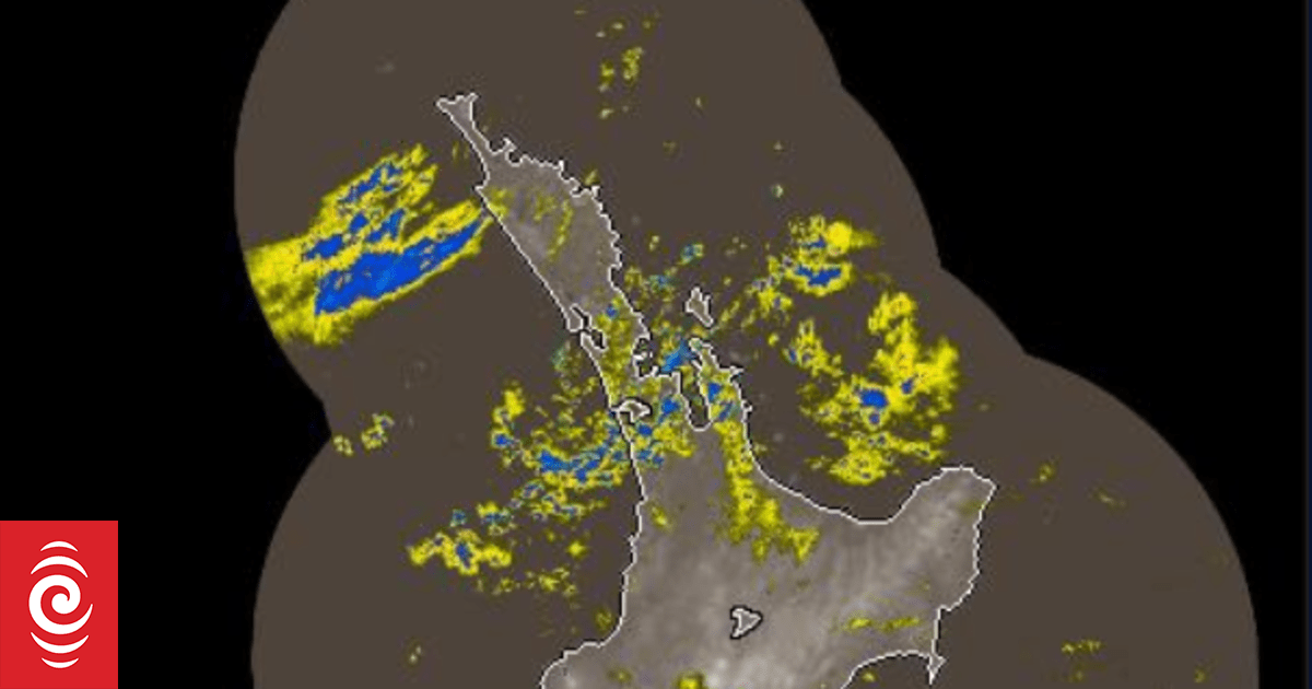
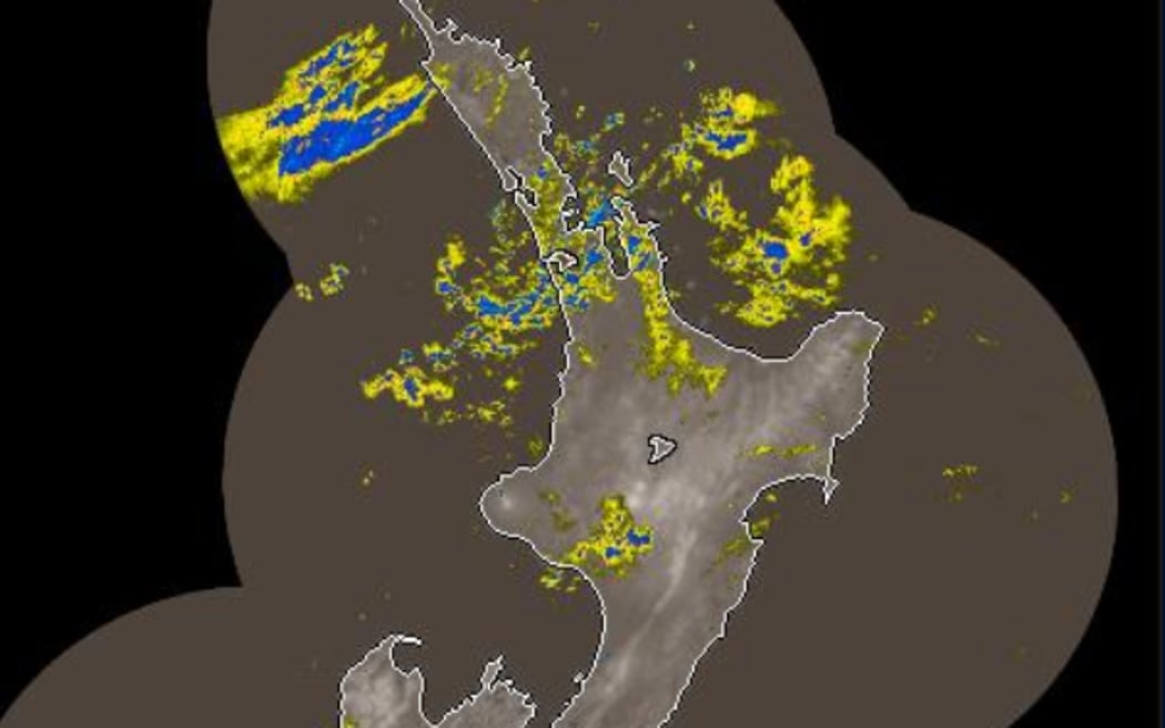
Northland received the most rain overnight, with Kaikohe reaching 200 millimetres in the past 24 hours to 6am.
In Thames-Coromandel, overnight downpours reached 81mm and more rain is expected throughout the day.
At 6am, Auckland was the wettest place in the country, with 25mm overnight, half of that was since 4am.
Intermittent bursts of rain were occurring in the central city.
Heads up upper North Island, including Auckland region and Coromandel.
Heavy rain is developing offshore.
Periods of heavy rain will occur this morning. Some rain will be torrential.
This afternoon, heaviest rain most likely Coromandel to BoP.
Risk for flooding/slips. pic.twitter.com/BQoEHIL0Rg
— NIWA Weather (@NiwaWeather) April 30, 2023
As the bad weather moved south, MetService said thunderstorms were expected in the Bay of Plenty area.
Fire and Emergency NZ said it had not yet received any weather-related callouts.
As of 6.30am, orange heavy rain warnings were in place for Northland, Coromandel, parts of Bay of Plenty, Tasman, north of Motueka, and Westland, south of Otira.
Yellow heavy rain warnings were in place for Auckland, including Great Barrier Island, parts of Bay of Plenty, including Gisborne.
Yellow strong wind warnings were in place for Auckland and Coromandel.
MetService said the bad weather was being caused by an “active front associated with a subtropical low” that was moving down the country.
It was “slow moving” and the rest of the week was looking “pretty unsettled”, Meteorologist John Law said.
Law said the warnings were being extended to Bay of Plenty as the day went on and MetService was “keeping a close eye” on the region on Monday and throughout the week.
The weather was also moving down to the South Island where western parts of the Tasman district were expected to “bear the brunt of the rainfall”.
Law told Morning Report it was “really worth” people keeping an eye on the forecast as “unfortunately more wet weather is to come” and warnings could be upgraded or changed.
As winter came, Law said it was likely northern parts of the country who were experiencing heavy rain events may become more settled as warm, moist air coming from the north was lost.
‘Keeping a close eye’
The Coromandel region appears to have handled the rain well, its district mayor says, but more would be seen throughout the morning.
Thames-Coromandel district mayor Len Salt told Morning Report the region was still in recovery mode from earlier severe weather events, including Cyclone Gabrielle.
Salt said 81mm of rain had fallen in the area overnight, but it appeared to have spread throughout the night, making it more manageable.
Teams had done “a lot” of work to prepare for heavy rain, such as clearing culverts so they could drain properly.
“At the moment, we are not in too bad a shape but nervously watching what is coming down the line,” Salt said.
“We seem to have come through OK but we are keeping a close eye on it.”
Salt said residents were also being asked to keep an eye on any differences they may notice in the land and let officials know if they had any concerns.
Auckland public transport affected
The weather in Auckland ferry services on Sunday, and that continued on Monday.
Auckland Transport said Gulf Harbour ferry services would be replaced with alternative transport because of the weather.
It included the 7.30am, 10.30am and 12.30pm services from Auckland to Gulf Harbour and the 6.30am, 7am, 7.30am, 8.30am, 11.30am and 1.30pm services from Gulf Harbour to Auckland.
On Monday 1 May 2023, the following Gulf Harbour Ferry services will be replaced with alternative transport due to weather conditions:
Auckland to Gulf Harbour at 07:30, 10:30, 12:30
Gulf Harbour to Auckland at 06:30, 07:00, 07:30, 08:30, 11:30, 13:30 pic.twitter.com/Rbp5YuF5HF— Auckland Transport Travel Alerts (@AT_TravelAlerts) April 30, 2023


