
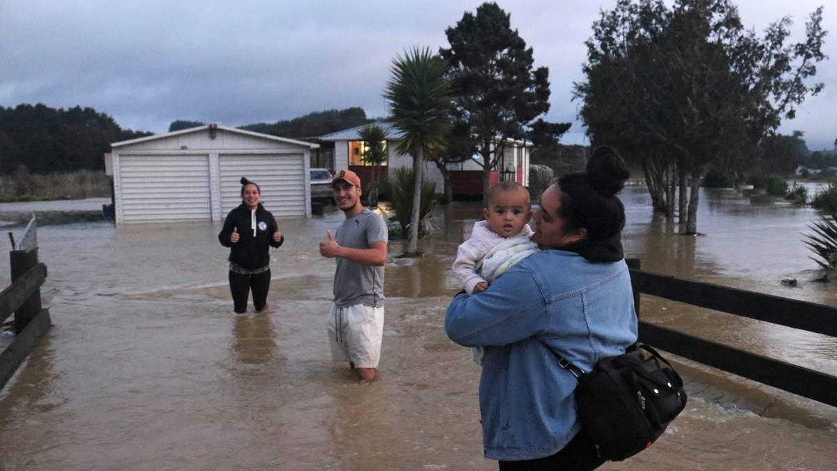
Gwen Ngawati (right) says goodbye to Mark Watene and Isabella Ngawati, with then-six-month-old son Elijah, as they evacuate the whānau’s Ōtiria Rd home in 2020. Photo / Peter de Graaf
Residents of a flood-weary Northland valley are praying a major spillway project will be finished before the next big storm hits.
Their calls come as MetService warns more heavy rain and strong winds are expected to hit the region from Thursday.
Moerewa and Ōtiria have been repeatedly affected by floods in recent years but had a narrow escape on Tuesday night last week when authorities were especially concerned for 15 households in Ōtiria Rd.
Police, firefighters and Civil Defence staff carried out checks and a welfare centre was set up in Moerewa in case they needed to evacuate.
Advertisement
The water stopped rising before it entered their homes, but several garages and sleepouts were flooded.
Several factors are behind the valley’s regular floods, including its geology and the sheer size of its catchment, but also man-made factors such as the construction of roads, a bridge and a railway.
Work has started on a multimillion-dollar flood mitigation project, paid for by mostly the Provincial Growth Fund, but it can’t come soon enough for stressed Ōtiria residents.
On Tuesday night, Gwen Ngawati went through the now-familiar exercise of lifting items in her garage out of reach of floodwaters and moving cars to higher ground.
Advertisement
On Wednesday came the equally familiar routine of cleaning out a thick layer of mud.
“It’s heartbreaking, not just for us but all our neighbours too,” Ngawati said.
“It would be great to get some sort of solution going. People who don’t live here don’t know what we go through.”
/cloudfront-ap-southeast-2.images.arcpublishing.com/nzme/HSYEDIGBRNGNVAQ7DFCXZ4COM4.jpg)
Ōtiria community advocate Pamela-Anne Simon said the flood rose at “unbelievable” speed.
Ngapipito Rd and Ōtiria Rd vanished under water as far upstream as Te Rito before the water drained away almost as quickly.
“It’s so stressful every single time this happens. We need to hurry up and get the spillway built. We’re nearly there, we’re just having a few issues.”
By contrast, Moerewa was “absolutely fine” after Tuesday’s deluge.
In the past the bridge on SH1 at the bottom of Turntable Hill would have flooded after so much rain.
/cloudfront-ap-southeast-2.images.arcpublishing.com/nzme/XGXR6ISBGJGI3A6QZMDZICAL4Y.jpg)
This time the swollen Ōtiria Stream reached the bridge deck but did not cover it, which Simon put down to flood reduction work carried out in 2021 by Waka Kotahi.
That project involved removing a bottleneck downstream of the bridge and giving floodwater space to spread out.
Advertisement
“It’s a blessing. Back in the day the water on the bridge would have been over my head,” she said.
Stage one of the Northland Regional Council’s Ōtiria-Moerewa flood mitigation spillway project, the construction of an 80m-long downstream section of spillway, was completed last year.
The present stage involves building a 60m bridge at Pokapu Rd to replace the 20m bridge blamed for diverting floodwaters from Ōtiria Stream and Waiharakeke River into the two townships.
Stage three involves excavating another 800m of spillway upstream from the bridge.
/cloudfront-ap-southeast-2.images.arcpublishing.com/nzme/BWQKWDLOUZH6FMNMKR5R6SEVVM.png)
Northland Regional Council rivers project manager Meg Tyler said construction of the new bridge had been delayed by ongoing wet weather, with the bridge foundations flooded four times so far this year.
Each time contractors had to wait for the river to drop before work could resume.
Advertisement
That meant the bridge was about three weeks behind schedule but once the foundations were complete, the construction site would be out of reach of flooding and the pace would pick up.
The bridge beams were due to be craned into place in late June.
The overall timeline was not affected by the delays, with the bridge still on track to be completed by mid-October and the entire project by the end of the year.
/cloudfront-ap-southeast-2.images.arcpublishing.com/nzme/A7DJ27ZVUBFS3IJKFS7O3XLBU4.jpg)
Last Tuesday’s flood had caused some scouring at the construction site but no major damage. Grass on the new spillway, which was still under water, would have to be resown.
Once the new bridge was finished the old one would be removed.
The old bridge had acted as a plug on Tuesday, preventing the mostly complete spillway from functioning, Tyler said.
Advertisement
Once the scheme was complete, floodwaters spilling from Ōtiria Stream would travel down the spillway, under the new bridge and into the Waiharakeke River, which had much greater capacity.
At present, when Ōtiria Stream floods, the excess water travels straight down Ngapipito and Ōtiria roads into Ōtiria township and then into Moerewa.
“This [last Tuesday’s flood] is exactly the type of event we’d expect the spillway to protect everyone against,” Tyler said.
/cloudfront-ap-southeast-2.images.arcpublishing.com/nzme/DUALNWA44FESJBNI5FAXOAECFE.JPG)
When planned, it was hoped the spillway could have been ready before the onset of winter.
The entire project is expected to cost $7 million with 57 per cent covered by Kānoa (the government agency that administers the former Provincial Growth Fund) and 28 per cent by targeted river rates. The remaining 13 per cent will come from the Far North District Council.
The project won’t prevent future floods completely, but it is hoped it will reduce their severity.
Advertisement
/cloudfront-ap-southeast-2.images.arcpublishing.com/nzme/7TXKAD25SVHIZCYQ6PMGBCZOFI.JPG)


