- Cyclone Gabrielle upgraded to a category 2 storm on Thursday morning and is expected to reach category 3 by Friday morning.
- Gabrielle is forecast to hit the upper North Island on Monday.
- Auckland mayor Wayne Brown says all Aucklanders need to be prepared for another potential severe weather event.
- It’s not yet clear which parts of North Island will be worst hit.
- The state of emergency in Thames-Coromandel has been extended.
- MetService hasn’t forecast severe weather past Tuesday, but rain is forecast for main centres nationwide on Wednesday.
Officials are preparing additional evacuation shelters for Aucklanders as Cyclone Gabrielle is expected to bring “significant severe weather” to the already soggy city.
The storm, currently over the Coral Sea, has reached category 2 and is now moving towards New Zealand.
It is expected to reach category 3 by Friday morning and hit Aotearoa on Monday where it is expected to affect the central and upper North Island, MetService says.
The Defence Force has also been brought in to help Auckland Council clear flood waste from kerb sides around Auckland and the existing state of emergency in the Thames-Coromandel District has been extended.
READ MORE:
* Tropical Cyclone Gabrielle set to barrel toward New Zealand
* Potential cyclone on track to hit North Island will form a day sooner
* Weekend brings rain, cold southerly gales, even some snow
According to MetService, a category 2 tropical cyclone has an average wind speed of between 89kph and 117kph.
A category 3 tropical cyclone, with the upgraded “severe” designation, has an average wind speed of between 119kph and 157kph.
Northland, Auckland, Coromandel Peninsula, northern and eastern Waikato, Bay of Plenty and northern Gisborne are expected to receive warning amounts of rain from Monday to Tuesday.
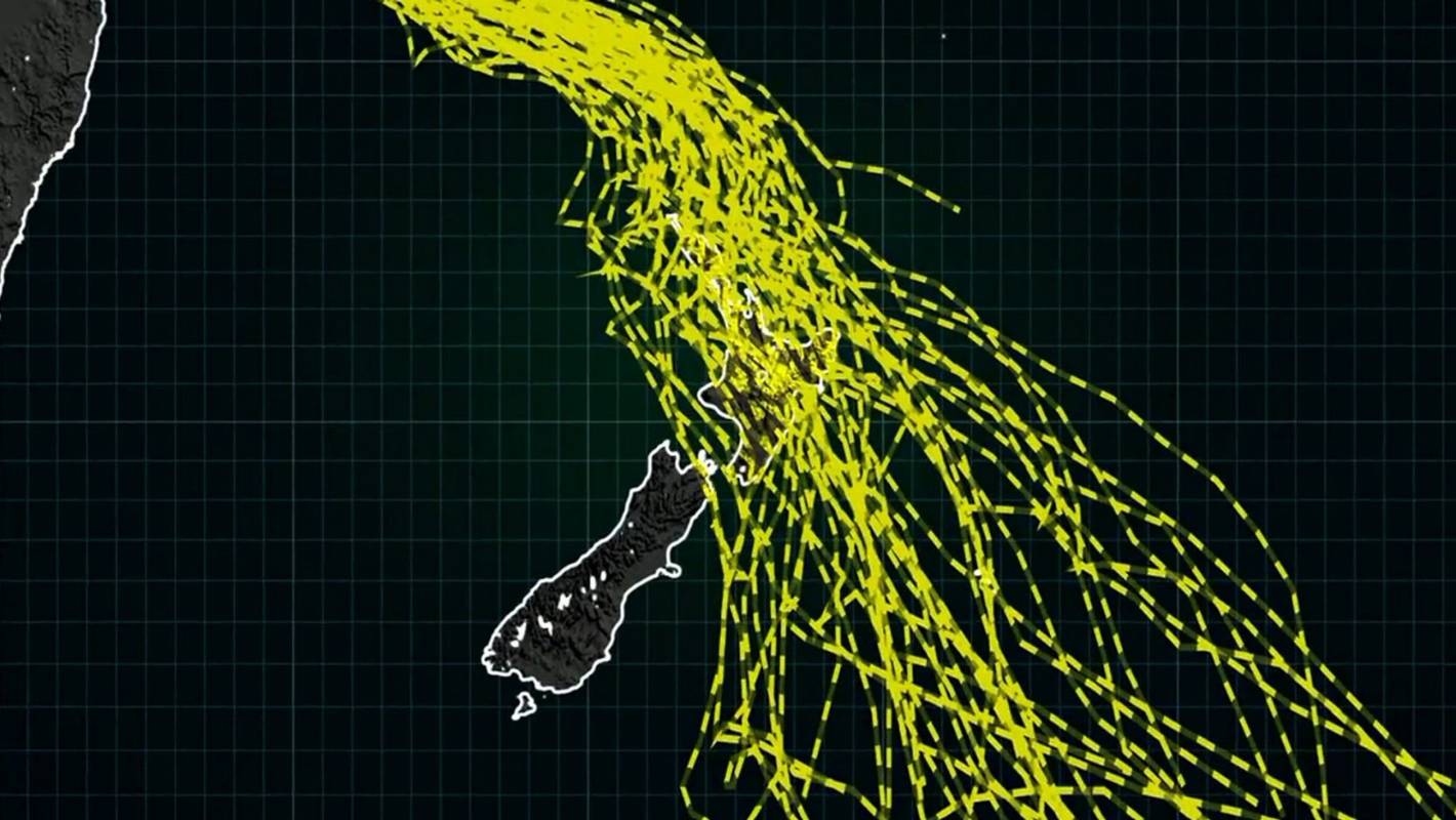
Niwa/Supplied
Niwa has forecast the potential paths Tropical Cyclone Gabrielle could take over New Zealand.
MetService said very large waves and a storm surge was expected to affect northern and eastern coastlines from Northland to Gisborne from Sunday into Monday.
More rain and a storm surge could lead to damaging winds, flooding rain and coastal inundation a fortnight after devastating rain hammered Auckland, bringing widespread flooding.
Wellington and the upper South Island might even be in the firing line, with severe gales predicted and a moderate chance of heavy rain for some easterly areas.
The Australian Bureau of Meteorology is predicting Cyclone Gabrielle will significantly strengthen over the course of Thursday.
MetService/Supplied
Cyclone Gabrielle is currently in the Coral Sea, but currently moving south southeast.
Gabrielle is currently moving in a south-southeast direction at 18kph, winds near the centre are 95kph with wind gusts to 130kph.
Northland might see severe gales and a warning amount of rain on Sunday, but the cyclone is expected to approach the North Island on Monday.
A projection published by Niwa on Thursday morning showed Gabrielle could hit almost anywhere in the North Island – including Auckland and Wellington.
An Auckland Emergency Management civil defence spokesperson said the team was preparing advice for Aucklanders and would have it ready later in the day.
On Wednesday, the Bureau of Meteorologynamed the system Tropical Cyclone Gabrielle after it officially formed out of a low pressure system.
At Thursday lunchtime, Gabrielle was sitting 580km off the coast of Queensland in the Coral Sea.
It is not expected to make landfall in Australia, but it is forecast to pass over Norfolk Island on Saturday. So far, no cyclone warning has been issued for Norfolk Island.
Then, the storm is forecast to turn southeast towards Aotearoa and move down the Coral and Tasman seas over the following few days, when it will strengthen.
MetService/Supplied
New Zealand is in the firing line for another lot of severe weather, with Tropical Cyclone Gabrielle making its way towards the country.
Weather forecasters are predicting heavy rain for Northland, Auckland, the Coromandel and the East Coast on Monday.
There remains uncertainty around the exact path of the cyclone as it approaches New Zealand, and how things play out will be determined in the coming days.
But, forecasters are expecting severe wind and rain for the upper North Island.
MetService has reminded the public that heavy rain could see rivers swell, surface flooding and slips.
Niwa meteorologist Chris Brandolino said, by Tuesday next week, some places could see well over 100mm of new rainfall.
The rain, he said, could exacerbate conditions in the already wet upper North Island and could lead to slips.
“We could be looking at a month’s worth of rain over some areas in a day or something like that … that’s a flooding risk.”
But if the cyclone travelled further west or east, much of the rain could end up in the sea.
“For people living in the upper North Island … from Sunday night through middle Tuesday, I’d keep a sharp eye on the forecast.”