
An orange heavy rain warning has been issued for cyclone-hit Gisborne, from Tolaga Bay northwards, as other warnings and watches are lifted.
Further heavy rain is expected in Gisborne, a weather warning remains in place until early Tuesday morning.
“A complex trough over the North Island, bringing heavy rain and isolated thunderstorms to parts of the Island, should weaken on Tuesday while moving away to the east,” MetService says.
A severe thunderstorm warning that was in place for Auckland has been lifted Monday night. Heavy rain watches were also lifted in Coromandel Peninsula and Bay of Plenty east of Kawerau as the threat of rainfall amounts reaching warning criteria has passed.
READ MORE:
* Two tropical cyclones potentially developing, impact to NZ ‘relatively low’
* Cyclone Gabrielle officially ‘one of worst storms in NZ’s living history’
* Cyclone Gabrielle: What will happen next and when will it be over?
Meanwhile, a new tropical cyclone, which was sitting north of Vanuatu on Monday afternoon, has been named Tropical Cyclone Judy by the Fijian MetService.
New Zealand’s MetService said it looked as if Judy would pass north of Aotearoa and would not have a “major impact on our weather”.
Another tropical low in the Coral Sea was expected to move east and move across close to Vanuatu late next week, MetService said.
Niwa
Heavy rain is set to hit Gisborne and Coromandel on Monday.
Shortly before 3pm on Monday, the MetService weather radar detected severe thunderstorms moving east, accompanied by very heavy rain and hail.
Thunderstorms were detected near Auckland, Ōrewa, Albany, Inner Hauraki Gulf and Whangaparoa and expected to hit from 3.15pm.
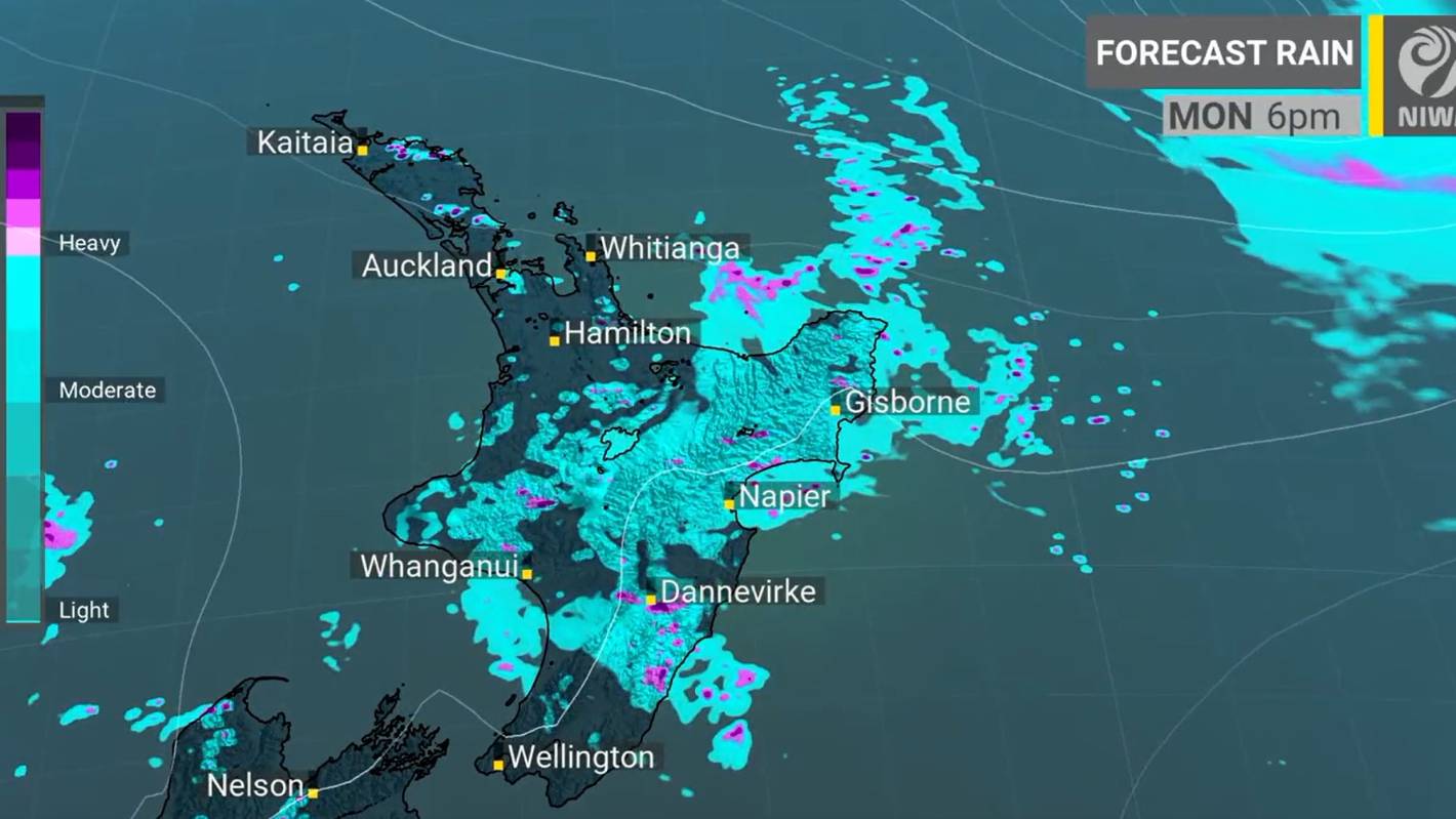
Gisborne from Tolaga Bay northwards is expected to be hit with 60 to 100mm of heavy rain from 3am Monday through till 4am on Tuesday, with localised downpours of 25 to 40mm/h likely on Tuesday morning.
From 9am Monday through till 3am Tuesday, the Coromandel Peninsula was expected to have periods of heavy rain with possible thunderstorms and localised downpours.
Bay of Plenty east of Kawerau was forecast to see periods of heavy rain with possible thunderstorms and rainfall potentially reaching warning criteria, between 7am to 4pm Monday.
Wayne Feisst/Supplied
Wayne Feisst captures some lightening and thunderstorm action in the Waikato, Reporoa, BOP area.
“Surface flooding is not an unreasonable expectation as another complex trough moves through the North Island,” MetService meteorologist Alex Holden said.
“It’s already really wet, so this will just be piling it on.”
Meanwhile, a severe thunderstorm watch was issued for much of the North Island from Monday afternoon until the evening.
The watch covered many parts of upper and central North Island between midday on Monday and 9pm, including Northland, Auckland, Waikato, the Kaimai Range, inland Waitomo, Taumarunui, southern Rotorua, Taupō, Taihape, northern Manawatū and inland Hawke’s Bay.
MetService forecasted the thunderstorms will be slow-moving with a moderate risk of becoming severe.
Meteorologist John Law said the risk of more thunderstorms could produce heavy downpours.
Auckland Emergency Management (AEM) issued a reminder to locals on Monday, urging them to “stay vigilant” as the threat of thunderstorms linger.
“These thunderstorms are expected to be slow moving, bringing localised heavy rain and hail for some,” AEM’s duty controller Fleur Aldridge said.
LAWRENCE SMITH/Stuff
Auckland Emergency Management have urged Aucklanders to look out for surface flooding during the possible heavy downpours.
“Rainfall of this intensity can potentially lead to surface or flash flooding in low-lying areas. We also urge everyone to be cautious when driving as conditions could be hazardous.”
AEM asked Aucklanders to continue staying calm, safe and prepared to leave should conditions become dangerous.
Power has been mostly restored in Auckland’s cyclone-ravaged west coast beaches Piha, Karekare and Muriwai.
MetService/Supplied
Two tropical cyclones are potentially developing.
In just over three weeks, 7000 homes have undergone building assessments.
As of 10am on Monday morning, 659 homes have red placards, 2245 have yellow placards and 4116 white placards.
These figures are a combination of houses and properties damaged during the January floods and Cyclone Gabrielle.
AEM also reminded Aucklanders to stay away from the west coast, which includes Karekare, Piha, Te Henga Bethells Beach, Muriwai, Anawhata, Huia Little Huia and Whatipū.
“Please continue to stay away from these areas and expect to be turned away if you are not a resident,” AEM said.
Some rain was also expected in Napier, another region hit badly by Cyclone Gabrielle.
Manawatu to Wellington and Wairarapa can expect fine spells with isolated showers.
Thunderstorms were possible from Monday afternoon in Nelson, Marlborough and Buller.
Odd showers were expected in Ōtautahi, South Canterbury, Otago, Southland, Westland and Fiordland.


