- Cyclone Gabrielle upgraded to a category 2 storm on Thursday morning and is expected to reach category 3 by Friday morning.
- Gabrielle is forecast to hit the upper North Island on Monday, with Northland, Auckland and Coromandel first in the firing line.
- Auckland mayor Wayne Brown says all Aucklanders need to be prepared for another potential severe weather event.
- It’s not yet clear which parts of the North Island will be worst hit.
- The state of emergency in Thames-Coromandel has been extended.
- MetService hasn’t forecast severe weather past Tuesday, but rain is forecast for main centres nationwide on Wednesday.
Auckland mayor Wayne Brown has extended the region’s state of emergency for another week as Cyclone Gabrielle descends.
The state of emergency has been in place since January 27, when torrential rain caused devastating flooding, killing four people.
The mayor announced the decision to extend the state of emergency in a statement on Thursday afternoon.
“My decision reflects the seriousness of the current and potential situation and our response,” he said.
READ MORE:
* Tropical Cyclone Gabrielle set to barrel toward New Zealand
* Potential cyclone on track to hit North Island will form a day sooner
* Weekend brings rain, cold southerly gales, even some snow
“After what Aucklanders have experienced since Friday 27 January, and with our region waterlogged, it will be a very serious situation if the current weather forecasts eventuate.”
Heavy rain watches have been issued for Northland, Auckland north of Whangaparāoa and Coromandel Peninsula from Sunday morning through to midnight Tuesday.
MetService said it was likely the watches would be upgraded to warnings in the coming days.
A strong wind watch is also in force for Northland and Auckland north of Whangaparāoa from 6am Sunday to midnight Tuesday.
Auckland south of Whangaparāoa and Coromandel Peninsula have a strong wind watch from 6am Monday to midnight Tuesday.
MetService said east to southeast winds “may approach severe gale” in exposed places.
“Metservice is expecting significant wind, rain and swell from this cyclone.”
Meanwhile, officials are preparing additional evacuation shelters for Aucklanders as Cyclone Gabrielle is expected to bring “significant severe weather” to the already upper North Island.
The number of Defence Force personnel helping clean up waste following Auckland’s flood is set to be doubled and the existing state of emergency in the Thames-Coromandel District has been extended.
Niwa/Supplied
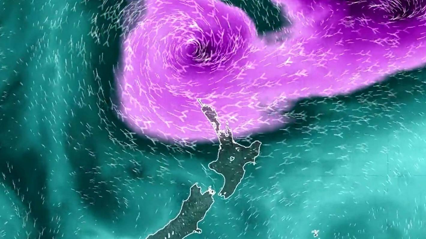
Cyclone Gabrielle is set to hit Auckland on Monday, but the first effects could be felt in Northland on Sunday.
The storm, currently over the Coral Sea, has reached category 2 and is now moving towards New Zealand.
It is expected to reach category 3 by Friday morning and hit Aotearoa on Monday where it is expected to affect the central and upper North Island, MetService says.
According to MetService, a category 2 tropical cyclone has an average wind speed of between 89kph and 117kph.
A category 3 tropical cyclone, with the upgraded “severe” designation, has an average wind speed of between 119kph and 157kph.
Northland, Auckland, Coromandel Peninsula, northern and eastern Waikato, Bay of Plenty and northern Gisborne are expected to receive warning amounts of rain from Monday to Tuesday.
MetService said very large waves and a storm surge was expected to affect northern and eastern coastlines from Northland to Gisborne from Sunday into Monday.
More rain and a storm surge could lead to damaging winds, flooding rain and coastal inundation a fortnight after devastating rain hammered Auckland, bringing widespread flooding.
Wellington and the upper South Island might even be in the firing line, with severe gales predicted and a moderate chance of heavy rain for some easterly areas.
Prime Minister Chris Hipkins has told Kiwis he wants everyone prepared for extreme weather events such as by having emergency supplies ready and a plan for what to do if there’s flooding.
“At a government level, we’re making sure that we’re ready to respond quickly when called upon to do so.
“But also, my message to New Zealanders everywhere, is that this is something we’re going to see more on,” Hipkins said.
The Australian Bureau of Meteorology is predicting Cyclone Gabrielle will significantly strengthen over the course of Thursday.
By Friday afternoon, the Defence Force would have 100 personnel in Auckland (40 Army, 30 Air Force and 30 Navy personnel) to assist with waste removal.
Niwa/Supplied
Niwa has forecast the potential paths Tropical Cyclone Gabrielle could take over New Zealand.
”Auckland authorities are concerned about the risk to people’s health from contaminated waste in and around people’s homes, and there is concern that with the more severe weather forecast that waterways could be potentially contaminated with kerb-side waste.”
Gabrielle is currently moving in a southerly direction at 15kph, winds near the centre are 95kph with wind gusts to 130kph.
Northland might see severe gales and a warning amount of rain on Sunday, but the cyclone is expected to approach the North Island on Monday.
A projection published by Niwa on Thursday morning showed Gabrielle could hit almost anywhere in the North Island – including Auckland and Wellington.
MetService/Supplied
Cyclone Gabrielle is currently in the Coral Sea, but is moving south southeast.
National leader Christopher Luxon said there was a lot to do to improve New Zealand’s emergency response system, but the Auckland flooding had shown community support at its best.
“Complete strangers” stepped up to help others remove carpet and furniture from their damaged homes, while schools and churches opened their doors to those displaced, he said.
There is no word yet on whether schools will close when the cyclone hits.
A Ministry of Education spokesperson said its incident management team “is keeping across the developing weather situation and will coordinate with the emergency management agencies leading the response”.
“All education providers have emergency management plans that are activated, when necessary.”
Far North mayor Moko Tepania said the council was on standby to open its emergency operations centre on Sunday if needed.
The Far North was no stranger to flooding events, he said: The district was still recovering from an August downpour which stranded residents and closed SH1 at Mangamuka.
“We’ve had more than just practice runs in Northland – we’ve learnt from the worst over my entire life.”
On Wednesday, the Bureau of Meteorologynamed the system Tropical Cyclone Gabrielle after it officially formed out of a low pressure system.
At Thursday lunchtime, Gabrielle was sitting 580km off the coast of Queensland in the Coral Sea.
It is not expected to make landfall in Australia, but it is forecast to pass over Norfolk Island on Saturday. So far, no cyclone warning has been issued for Norfolk Island.
Then, the storm is forecast to turn southeast towards Aotearoa and move down the Coral and Tasman seas over the following few days, when it will strengthen.
Weather forecasters are predicting heavy rain for Northland, Auckland, the Coromandel and the East Coast on Monday.
There remains uncertainty around the exact path of the cyclone as it approaches New Zealand, and how things play out will be determined in the coming days.
But, forecasters are expecting severe wind and rain for the upper North Island.
MetService has reminded the public that heavy rain could see rivers swell, surface flooding and slips.
Niwa meteorologist Chris Brandolino said, by Tuesday next week, some places could see well over 100mm of new rainfall.
The rain, he said, could exacerbate conditions in the already wet upper North Island and could lead to slips.
“We could be looking at a month’s worth of rain over some areas in a day or something like that … that’s a flooding risk.”
But if the cyclone travelled further west or east, much of the rain could end up in the sea.
“For people living in the upper North Island … from Sunday night through middle Tuesday, I’d keep a sharp eye on the forecast.”