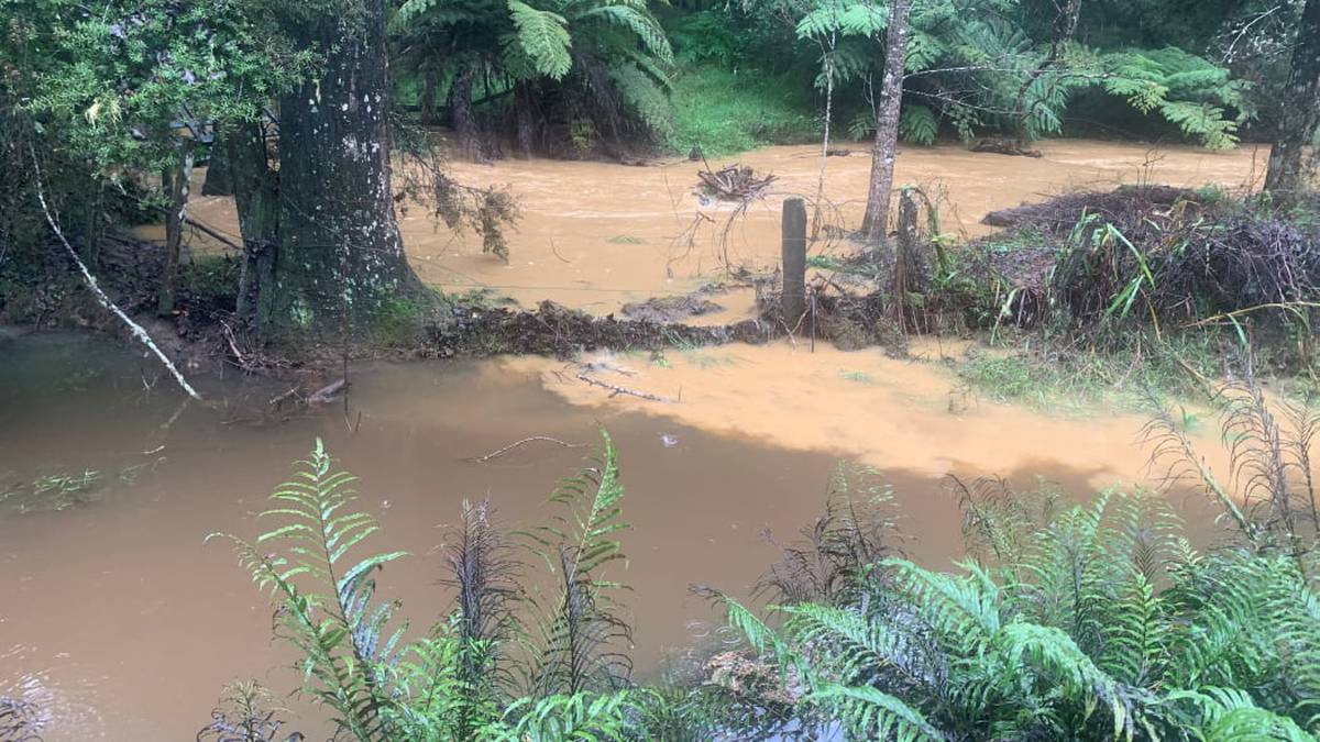
Sediment-laden water gushes through Shayne Tobin’s property near Kaikohe in Northland. Photo / Supplied via RNZ
By Peter de Graaf of RNZ
Record-breaking rainfall in parts of Northland is heightening concerns about huge volumes of sediment washing into the region’s streams and harbours.
Research has found 500,000 tonnes of eroded soil ends up in the Bay of Islands alone every year.
That is equivalent to a 10-tonne dump truck load every 10 minutes, 365 days a year – and that is for just one of Northland’s 10 harbours.
Advertisement
The loss of topsoil threatens Northland’s economic base, while thick layers of slimy sediment deposited in streams and estuaries smother marine life and important food sources such as shellfish.
Shayne Tobin, who has been working for many years to restore the stream that runs through his property south of Kaikohe, sees the problem first-hand.
/cloudfront-ap-southeast-2.images.arcpublishing.com/nzme/3MGZXQSJ5ZGLJIDCMEFRKCEVM4.jpg)
He had fenced off the stream to keep stock out, planted more than 7000 trees, and in 2019 placed part of the property under a QEII covenant to protect it in perpetuity.
However, his work was being undone by a torrent of mud and silt any time it rained.
Advertisement
Tobin said the stream used to run clear even during heavy rain.
“But now, anything over 20 millimetres in 24 hours, it just turns into something like an Amazon, a chocolate mass of mud.”
The loss of water clarity was depressing, he said.
/cloudfront-ap-southeast-2.images.arcpublishing.com/nzme/WIIQIZRHXFD7NGZZDDES5GBTJU.jpg)
“The locals used to come and take watercress but we don’t take it ourselves anymore because it’s just not healthy.”
A deep pool had silted up, stream banks had been scoured out, and plantings had been washed away.
His real worry, however, was what was happening downstream.
The stream drains into the Taheke River, which flowed into the Hokianga – one of New Zealand’s most culturally significant harbours.
Tobin said the problem started about four years ago.
He put it down to land use upstream that just was not suitable for an area with poor-draining soils and high rainfall.
The problem was accelerating around Northland as more and more land was cleared and sprayed, he said.
Advertisement
On the opposite coast, Rana Rewha, a kaitiaki for Rawhiti hapu Ngati Kuta, said he had observed stark changes in the Bay of Islands during his lifetime.
Sea grass that used to grow in the bays had been replaced by silt and shellfish were smaller than they used to be.
/cloudfront-ap-southeast-2.images.arcpublishing.com/nzme/RNUDIHKTYNHLPBUART2HPCFNZA.JPG)
“We don’t know if it’s connected yet, but we’ve lost most of our pipis, and the cockles are not up to their natural size.
“The old size we remember was more than double the size they are now. That’s just one effect.”
The huge tide of sediment has also been ringing alarm bells at the Northland Regional Council.
Councillor Amy Macdonald said more than 60 per cent of Northland was classified as highly erodable, due to steep terrain, underlying geology, and soil types.
Advertisement
That erosion then led to sediment entering the region’s waterways.
“We just happen to have a landscape which is quite vulnerable. In addition we have a climate which includes a lot of heavy rainfall events.
/cloudfront-ap-southeast-2.images.arcpublishing.com/nzme/T7HI7SEFWZ4MITC6FFTGREGAYQ.jpg)
“When we see those extreme rainfall events happening, that’s often when our biggest sedimentation events happen.
“With climate change predictions looking like we will see increased frequency of heavy rainfall across our region, we have an uphill battle dealing with slipping and slumping in our hill country, and a lot of stream bank erosion when our streams come up really high. It’s a big challenge.”
Sediment was a problem for several reasons, Macdonald said, in the first instance because the loss of soil took away Northland’s economic base.
And when sediment entered waterways, marine life was smothered, aquatic plants could not photosynthesise, and food sources that fish depended on disappeared.
Advertisement
“When we move from a healthy stream that doesn’t have sediment to one that is smothered in fine sediment there’s a really big change in the whole ecosystem,” Macdonald said.
“The invertebrates and critters that live in a healthy stream can’t tolerate that level of sedimentation.
“They will be replaced by sediment-tolerant species like different types of worms and snails … The effect is similar in estuaries if they change from a sandy base to a muddy, sediment-laden base.”
The effect on shellfish was a major concern, she said.
“Shellfish are a really important part of our lifestyle here in the Northland, and they just can’t occupy spaces that are too silted up.”
Landowners could help by fencing wetlands and streams, removing stock from waterways, and contacting the regional council to identify areas vulnerable to erosion and find out what support was available.
Advertisement
The council had received $1.7 million from the Ministry for Primary Industries to assist landowners with resources and advice.
Tangata whenua and the regional council were working together on a project to combat sedimentation in the Hokianga Harbour, based on a successful remediation project in the Kaipara.
/cloudfront-ap-southeast-2.images.arcpublishing.com/nzme/PM2DR6X4VJEB7JCPA2ZKMJ4D7Q.jpg)
The council was also undertaking a Freshwater Plan change, which would update the rules around land use and its impact on waterways.
“The health of our coastal environment is fundamental to the health of our people here in Northland,” Macdonald said.
“We are coastal people, we recreate, we gather food, we get our well-being from being on the coast and on the water, so making sure our streams and estuaries are healthy and free of sediment means our whole coastal environment will be healthy.”
In total, MPI has allocated $25m from its Hill Country Erosion Programme to 14 erosion-prone regions over the next four years.
Advertisement
Landowners who want to apply for some of Northland’s $1.7m share can email landadmin@nrc.govt.nz or call 0800 002 004 and ask to speak to a land management adviser.


